
Sierra Helada Hike 2026: Albir to Altea Coast Path Guide
 Wesna Group
The Sierra Helada ridge rises 438 metres straight out of the sea between Albir and Benidorm. Here is how to walk the easy lighthouse path, the full traverse, where to park, and when to go in 2026.
The Serra Gelada natural park covers 5,564 hectares between Alfaz del Pi, Altea and Benidorm, with cliffs that drop almost 400 metres into the sea and a ridge topping out at 438 metres on the Alt del Governador. Most visitors only walk the paved 2.5 km to the Albir lighthouse and turn back. The real hike is the ridge above it, still free in 2026, and no beach stroll.
What is the Sierra Helada hike and where does it start?
The Sierra Helada hike is any walk inside the Parc Natural de la Serra Gelada, a limestone ridge that runs roughly 6 km along the coast from the Racó de l'Albir in the north to the Cruz de Benidorm and Punta del Cavall in the south. It became the first mixed land-and-sea natural park in the Valencian Community when it was declared in 2005, and the Generalitat Valenciana manages it today.
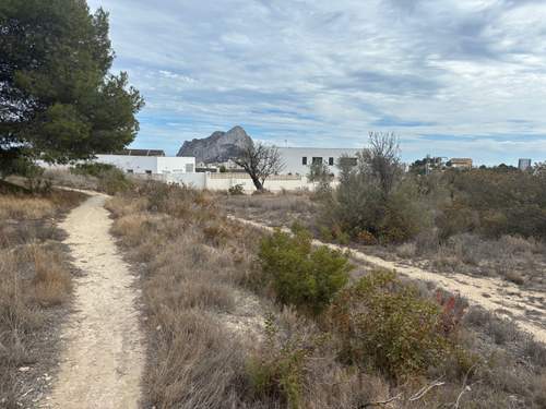
There are three practical starting points. The busiest is the free car park at the end of Camí Vell del Far in Albir, which feeds the paved lighthouse track. A second trailhead sits behind the Rincón de Loix in Benidorm and climbs to the Cruz. The third, used by locals and more serious walkers, starts in Altea beside the Mascarat or above the cemetery, giving access to the north face and the ridge from the quieter side.
The most photographed route is the lighthouse walk, finishing at the Faro de l'Albir, a working lighthouse first lit in 1863 and still operated by the Autoridad Portuaria de Alicante. The most rewarding is the ridge traverse that passes the Alt del Governador, the old watchtower ruins and the Cruz de Benidorm, with the sea 300 metres straight down on your left.
Which route should you pick, lighthouse walk or ridge traverse?
Pick the route to match your fitness, your footwear and how much sun you can tolerate. The two options are very different walks.
Faro de l'Albir path. 5 km round trip, paved the whole way, 80 m of climb. One hour out and back at a slow pace, two with children stopping to look at the cliffs and the old ochre mine. Pushchair-friendly up to the first viewpoint, then the gradient tightens a little. This is the walk for grandparents, toddlers and anybody not in hiking shoes. Open from early morning to sunset, with the park gate typically shutting the vehicle track around 20:00 in summer and 18:00 in winter.
Ridge traverse to the Cruz de Benidorm. Roughly 13 km point to point if you walk Albir to Benidorm, 6 to 7 hours with stops, about 600 m of cumulative climb. Marked as PR-CV 12. Rocky, exposed, zero shade above the pine line, and the drops on the seaward side are vertical. You need proper trail shoes, at least two litres of water per person, and a plan to get back, since there is no loop. Most people arrange a taxi from the Cruz back to Albir, around EUR 20 to 25.
Short summit option. From the Albir side you can climb to the Alt del Governador and come back the same way in about 4 hours. This gives you the best view in the park without committing to the full traverse.
| Route | Distance | Time | Difficulty | Shade |
|---|---|---|---|---|
| Faro de l'Albir | 5 km | 1 to 2 h | Easy | Light pine at start |
| Alt del Governador out and back | 9 km | 4 h | Moderate | Almost none above 200 m |
| Full traverse Albir to Cruz de Benidorm | 13 km | 6 to 7 h | Hard | None |
When is the best time to hike Sierra Helada in 2026?
October to April. Between May and September the exposed ridge regularly sits above 32 degrees by late morning with no shade and no water source on the trail, and the mountain rescue service in Alicante pulls heat-exhausted walkers off it every summer week. If you must walk in July or August, be on the path by 07:00 and off it by 10:30.
The sweet spot for the full traverse is November, February and March. Daytime temperatures of 16 to 22 degrees, dry underfoot, and the light is low enough that the cliffs photograph properly. December and January work too but days are short, so start by 09:00 for the long route.
Avoid the week of Semana Santa if you want solitude. The lighthouse path can see 2,000 walkers on a sunny Easter Sunday and the Albir car park fills by 10:00. Weekday mornings in November are the opposite experience: often you share the ridge with a handful of people and a lot of Audouin's gulls.
For the 2026 park calendar, guided visits and any temporary trail closures, check the Generalitat Valenciana's official park page at parquesnaturales.gva.es. Closures for fire risk do happen in high summer and are posted there first.
How do you get to the trailhead and where do you park?
From Albir, drive or walk to the end of Camí Vell del Far. The last 400 metres are a narrow residential street. There is a free gravel car park at the park entrance with about 80 spaces. In high season it fills before 10:00 and cars start parking along the approach road, which the Alfaz del Pi police do ticket. The sensible move is to park in central Albir and walk the extra 15 minutes.
From Benidorm, the Cruz trailhead is reached from Calle Sierra Dorada behind the Rincón de Loix. Street parking only, difficult in summer. Bus line 10 from central Benidorm drops you within 20 minutes of the start.
From Altea, the north-side approach starts near the municipal cemetery above the old town. Parking is easier here than in Albir but the trail is rougher and less signed, so it is a route for walkers who already know the park.
There is no entry fee to the park or any of the trails. There are no toilets on the mountain. The small visitor information point at the Albir trailhead opens most mornings in season and sells a basic trail map for a couple of euros.
Public transport from further afield: the TRAM line 9, which runs Benidorm to Denia, stops at L'Albir station, a 20-minute walk from the trailhead. From Alicante, take line 1 to Benidorm and change to line 9. From Benidorm centre to Albir is 25 minutes on the TRAM.
What should you bring and what are the safety risks?
The lighthouse path is a relaxed family walk and needs little more than water, sun hat and sensible shoes. Everything beyond it is a proper mountain day.
For the ridge, pack:
- 2 litres of water per person minimum, 3 in warm weather
- A hat and high-factor sunscreen, reapplied
- Trail shoes with grip, not trainers
- A paper map or downloaded GPX, since phone signal drops in several sections
- A light windproof, as the ridge catches the sea breeze even in summer
- Snacks with salt, as there is nowhere to buy food between Albir and Benidorm
The real hazards are heat, exposure and the cliff edge. The seaward side of the ridge has unfenced drops of over 300 metres in several places. Dogs on long leads, selfie backstepping and wet rock after rare rain are the recurring themes in local rescue callouts. Keep well back from the edge, especially where the path narrows between the Alt del Governador and the Cruz.
Wildfire is a seasonal concern. The park sits on dry pine and scrub and has burned in living memory. Barbecues and cigarettes are prohibited across the park. During declared high-risk days the Generalitat may close trails at short notice, and fines are real.
Mobile coverage is patchy on the north face and inside the gullies. The European emergency number 112 works where there is signal. Tell someone your route and expected finish time, especially for the full traverse.
What else is worth doing in the area?
The park sits between two of the most liveable towns on the Costa Blanca North, so most hikers combine it with a slow lunch and a swim. Our local guides to Alfaz del Pi and the Albir area and to Altea Hills explain why both towns keep pulling northern European buyers. Albir's pebble beach is a five-minute walk from the trailhead and has lifeguards until October. The old town of Altea, with its blue-domed church and tight whitewashed streets, is 10 minutes by car.
If you want more coast walking, the Calpe climb up the Peñón de Ifach is a short, sharp afternoon with a tunnel and a summit view. For a bigger inland day, the Sierra Aitana trails above Polop and Benifato take you to the highest point in the province at 1,558 metres. Road cyclists will know the Calpe to Denia coast route that uses the N-332 and the inland lanes. For swimming afterwards, several of the hidden coves of the Costa Blanca North are within a 30-minute drive.
FAQ
Is the Sierra Helada hike free? Yes. There is no fee for any of the trails, no booking requirement for individual walkers and no charge for the Albir trailhead car park. Guided group visits run by the park authority are also free but need to be reserved through the Generalitat Valenciana park office.
Can I walk to the Albir lighthouse with a pushchair or wheelchair? The track is paved and mostly gentle, and most pushchairs handle it. Wheelchair users manage the first kilometre comfortably; the final climb to the lighthouse viewpoint is steeper and can need a push. There are benches and shaded rest spots along the way.
Are dogs allowed in the park? Dogs are allowed on leads on the lighthouse path and the main marked trails. They are not allowed off the paths, inside the strict reserve zones, or on the cliff edges. Bring water for them, as there is none on the mountain.
How dangerous is the full ridge traverse? It is not a technical climb, but the exposure is real. Several sections have long unfenced drops to the sea. In good weather, in proper footwear, with a sensible early start, a fit adult walker handles it without difficulty. In summer heat or after rain it has sent people to hospital. Do not take young children on the traverse beyond the Alt del Governador.
When does the park close? The trails themselves do not close; the vehicle gate at the Albir car park has seasonal hours, typically 08:00 to 20:00 in summer and 08:00 to 18:00 in winter. Check the official park page before driving up in low season, since the gate times shift.
Next steps
Walking the ridge often changes how buyers see the villages below it. Browse current sale stock in Alfaz del Pi, the closest town to the Albir trailhead, and we can line up viewings for the following morning.
Get our Costa Blanca property guides
One short email a month with new neighborhood guides, market notes, and rule changes. No spam, unsubscribe in one click.
We use your email only for the newsletter. Read our privacy policy for details.